Well readers, a bunch of things have happened in the last couple weeks, and I just haven't had the time to sit down and write about them! A couple of weeks ago you may have read that I was preparing for a Mt. Whitney hike, and two weekends ago, we did it!
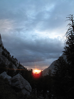
The photo to the left here is the sunrise from about 10,000 feet. It's around 6:00am in the morning. After two downpours (you can see the storm clouds in the foreground), I took this picture as we looked back into the valley. We started the trek at 2:30am, when we woke up and prepared to hit the trail. After a quick breakfast and backpack prep, we started on the Mt. Whitney trail at 3:20am. We hiked for the first 2.5 hours in the dark, just following our headlamps as they bounced around the terrain. At around 5:30am we could faintly see our surroundings, and at 6:00 we could turn off our headlamps and see the trail ahead. Our route started at 8,200 feet, and we had done the first three miles of the hike by 6 am. Good time. The route itself has a quota of 100 people per day that are allowed to day hike the mountain. So here we are, at ten thousand feet, taking a picture of the rising sun breaking through the clouds, and it's drizzling. Luckily, it only gets better as we go further up the mountain. As the clouds clear out, it becomes a very nice day!
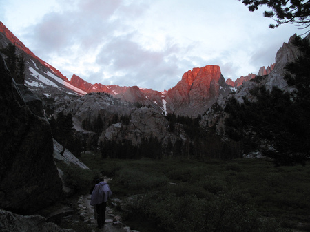
The above photo was taken just as we crest into Outpost Lagoon, a lush, level field with several streams running through it, This was at around 5:45am. The folks ahead are part of our hiking party, five of us in total. There is a backpacking site further into the lagoon area, which you need a wilderness permit to use. As we climb higher and higher, the air gets thinner! Luckily, we acclimated to about 8200 feet, so most of us are used to this much higher elevation. At around six miles into the hike, at 12,000 feet, we hit the next backpackers campsite, Trail Camp. This site is situated at the foot of a series of switchbacks which rise 2.8 miles up in the span of less than half a mile. Very steep. At this same campsite, we are also just five miles away from the summit! A little more than halfway. Unfortunately, both myself and a hiking partner had reached our tolerance limit for wind and cold. We were just not prepared to hike the remaining five miles to the summit. With the windchill it was approaching 40
° Fahrenheit! After the downpours earlier in the hike, we were definitely winded and cold. However I did
take this panorama of the Trail Camp area, so take a look and see the amazing views at 12,000 feet. Click to see the original size if you dare. It's big. If you look carefully, you can compare the size of the people and the rock faces. They are located towards the left of the photo. If you would like to see more photos from the trip, check out
the Flickr photostream. I've also added short commentary on what each photo is, so read those as well!


Leave a comment